The Kingdom in the Sky
Lesotho is a country that exists entirely above 1,000 meters. Not parts of it. All of it. It holds the record for the highest lowest point of any nation on earth. The whole country is up.
It sits inside South Africa. Completely surrounded by it. An enclave with its own language, its own currency, its own king, and its own way of doing things. You cross the border and the landscape changes, the roads change, the pace changes. You are somewhere else.
Most people come through the Sani Pass from KwaZulu-Natal, have a beer at the top, and turn around. That's fine. But Lesotho is more than a border crossing with altitude. It's mountains that don't end. Villages reachable only by foot or horseback. Roads that test your vehicle, your patience, and occasionally your will to live.
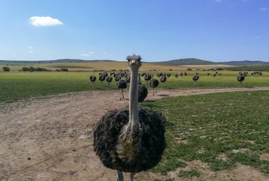
The Basotho people wear traditional blankets like a national uniform. Ponies are still a serious mode of transport. Shepherds watch over cattle in valleys that look like they haven't changed in centuries. Lesotho doesn't try to impress visitors. It barely notices them.

The Roads
Some roads in Lesotho are the best I've ever driven. Smooth tarmac cutting through mountain scenery that makes you want to stop every 500 meters for a photo. The northern part in particular is easy to navigate, well maintained, and genuinely pleasant.

Then there are the other roads.
Some of the mountain roads in Lesotho are the worst I've ever driven. And I've driven many offroad tracks in various countries. The difference here is that these aren't marked as offroad. They're on the map as roads. Google will route you along them. Your GPS will cheerfully tell you to continue for 47 kilometers as if that's a normal thing to do on what turns out to be a boulder field with cliffs on one side.
The contrast is striking. You can go from perfect tarmac to near-impassable rock track within a few kilometers. There's no warning. No sign that says "from here on, good luck." It just happens.
The Mountain Crossing

I drove up the Sani Pass with a 4x4 rental. Normal SUV clearance, nothing extreme. That was totally fine. Steep and winding, yes, but manageable. The views from the top are worth every switchback.
Then I decided to continue north. The tarred main road, Route 41 between Tlokoeng and Letseng, was decent tarmac but came with its own surprises. In some places, huge boulders had recently fallen from the cliffs above and were just sitting in the middle of the road. You could see the fresh marks on the rock face. That's when you start thinking about what happens when a multi-ton rock meets a car at speed. You don't think about it for long because the next one demands your attention.
From Tlokoeng, I turned toward the Katse Dam. That was a different level entirely.
The road got worse and worse. At some point it stopped being gravel and became rocks. Not small rocks. Boulders. The kind where you have to navigate around them on a road barely wide enough for one car, with a deep cliff dropping away on one side and no guardrail, no barrier, nothing between you and a very long fall.
There were stretches where I covered 5 kilometers in one hour. Massive holes threatened to rip the undercarriage off the car.
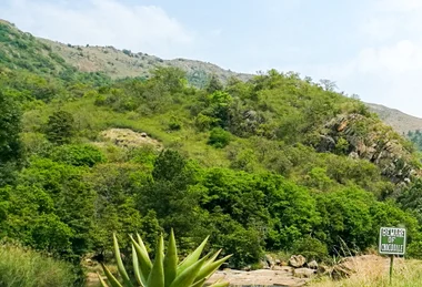
The landscape through all of this was spectacular. Absolutely stunning. Mountains folding into mountains, valleys dropping away into nothing, light changing every few minutes. It's the kind of beauty that's hard to appreciate when you're gripping the steering wheel with both hands and wondering if this was a good idea.

Two kilometers further, the road got even worse. I could see what was coming ahead and it was clear my car wouldn't make it. Not before dark, at least. And staying overnight in freezing mountain temperatures on a road where one car barely fits is not something anyone should do voluntarily.
I turned around. Sometimes the smartest thing you can do is admit that the road won.
My learning for you: Don't attempt some roads in Lesotho with an SUV. If you wanna explore Lesotho's center, get a proper high-clearance offroad vehicle.
The Kids on the Road
On one stretch of mountain road, in the middle of nowhere, I saw kids standing by the side. They were picking up small stones and placing them into the biggest holes in the road. Filling them in. When they saw my car approaching, they stepped aside and gestured at their handiwork.
I didn't know what this was about, so I drove past. They threw stones after my car.
Here's what I learned later: this is how these kids earn money. They fill the holes when they see a car coming. The driver pays them. When the car leaves, they take the stones out again. Fill, open, repeat. It's a business.
The government says you shouldn't pay them, not with money, not with sweets, because they skip school to do this. But if you don't pay, they might damage your car. It's one of those situations where there's no clean answer.
Two kilometers further, another group of kids stood on the road, rocks in their hands. I stopped and asked if any of them spoke English. One boy did, a little. I asked if the road would get better. He said it would, after a few kilometers. But first it gets worse.
I asked if I would make it in my car. He looked at me. Then at the car. Then at me again.
"Sir, with this car, you will crash and you will die."
Very motivating. I gave them some money, which they accepted politely. I continued for another kilometer before the road confirmed that the boy was probably right. That's when I turned around.
The Police
In the northern part, I had an encounter with the police. They stopped me at a checkpoint and found that the inspection of my South African rental car had expired. I couldn't continue driving.
I was nervous. I had no idea how the police works in Lesotho. Is bribing common? Should I offer something? Or would that land me in prison? I watched the situation carefully for about 30 minutes and didn't see anyone giving the police anything.
The chief officer of the group was polite. Professional, even. He called my rental company, explained the situation, and arranged the exchange. Then three police officers got into my car and told me to drive. I expected the worst.
Turns out, they don't have enough police cars. So they use other people's vehicles. I was now an unpaid taxi for the Lesotho police. We drove to the next village, where I had to wait for four hours until the replacement car arrived.
The police chief checked on me when he realized I was still waiting. He told me that if the new car doesn't arrive in 15 minutes, he will personally take care of the rental company. Ten minutes later, the car showed up. Coincidence? Maybe.
Then I watched the same policemen stop some passing cars, load their road barricades and checkpoint signs into the trunks, get into the backseats, and drive off. To the next checkpoint, presumably. It's a system. Not the one I expected, but a system that makes the most out of the situation.
Culture and the Basotho Blanket
Lesotho has a cultural identity that's stronger than you'd expect from a country this small and this poor. The Basotho people have maintained traditions that go back centuries, and they're not preserved in museums. They're lived, daily, visibly.
The most recognizable symbol is the Basotho blanket. Not a souvenir blanket. Not a decorative throw. A real, functional garment that people wear every day, draped over the shoulders like a cloak. The blankets have specific designs, each with meaning. The Seanamarena design, featuring a corn cob motif, is one of the most traditional. Some patterns are associated with royalty, others with specific occasions like weddings or funerals. A Basotho blanket is not just warmth. It's identity.
The blankets are made from wool and are surprisingly heavy. They're produced commercially now, primarily by a South African manufacturer, but the tradition of wearing them is entirely Basotho. You see them everywhere: on shepherds in the mountains, on women at markets, on men walking along the road, on kids going to school. In a world where traditional clothing often becomes a costume for tourists, the Basotho blanket is the opposite. It's everyday clothing that happens to have deep cultural significance.
Outside of Lesotho, these blankets have gained a following. Fashion designers have referenced them, collectors seek out vintage patterns, and they occasionally appear in international media. Inside Lesotho, none of that matters. People wear them because they've always worn them, because the mountains are cold, and because a blanket says something about who you are.
The Basotho hat, the mokorotlo, is equally iconic. It's a conical straw hat that appears on the national flag. You see it less often in daily life than the blankets, but it's still a proud symbol. The shape is said to represent Mount Qiloane, a flat-topped peak near Thaba Bosiu, the mountain fortress where King Moshoeshoe I founded the Basotho nation in the 1820s.

Thaba Bosiu itself is worth knowing about. It's a sandstone plateau near Maseru where Moshoeshoe I established his stronghold, successfully defending against multiple invasions. It's considered the birthplace of the Basotho nation and remains a place of cultural significance. The ruins are modest, but the history is not.
Ponies are part of Basotho culture in a way that goes beyond transport. The Basotho pony, a sturdy breed adapted to high altitude, is the traditional way to move through the mountains. In remote areas, ponies are still more practical than vehicles. Pony trekking is one of the main activities offered to visitors, and it's one of the better ways to see the highlands the way the Basotho have seen them for generations.
What to Do

Drive the mountain passes. This is the main event. The roads through Lesotho's highlands are some of the most dramatic drives in southern Africa. The Sani Pass is the famous one, but the routes through the central mountains, if your vehicle can handle them, are equally spectacular. Even the paved roads in the north offer mountain scenery that rivals anything on the continent.
Pony trekking. Available from several lodges, including Semonkong. You ride Basotho ponies through the mountains, visiting remote villages that are inaccessible by car. It's slow, physical, and gives you a perspective on the landscape that driving doesn't. Rides range from a few hours to multi-day treks with overnight stays in villages.
Maletsunyane Falls. Near Semonkong. One of the highest single-drop waterfalls in southern Africa, plunging about 192 meters. The hike to the base takes a few hours and is worth it. The falls are most impressive after rains.
Katse Dam. The Katse Dam is part of the Lesotho Highlands Water Project, one of the largest water transfer schemes in Africa. The dam itself is impressive, and the surrounding reservoir sits in a dramatic mountain setting. There's a visitor center. The engineering alone is worth the trip, if the road doesn't stop you first. Best to approach it from the north on a proper road.
Thaba Bosiu. The mountain fortress near Maseru where King Moshoeshoe I established the Basotho nation. It's a relatively easy hike to the top, and the views across the surrounding plains are wide. The historical significance is what makes it special. Guides are available and recommended.
Buy a Basotho blanket. Not from a tourist shop in South Africa. From Lesotho. The blankets are available in Maseru and at markets throughout the country. They're not cheap (a good one costs the equivalent of 50 to 100 dollars or more), but they're the real thing. A blanket bought in Lesotho is a different object than a blanket bought about Lesotho.
What to Skip
The Sani Pass beer-and-turn-around. The most common way to "visit" Lesotho is to drive up the Sani Pass from South Africa as an organized trip, have a beer at the highest pub in Africa, take a photo, and drive back down. You've technically been to Lesotho. You haven't experienced it. If you're making the effort to get up there, keep going. And, seriously: If you wanna do the Sani Pass, then do it on your own. Take the steering wheel and drive it yourself. Sitting in the back of a Jeep is not even 1 % of the experience.
Maseru as a destination. Maseru works as a transit point and supply stop. It doesn't work as a place to spend multiple days. The mountains are why you're here, and every hour in Maseru is an hour not spent in them.
Driving mountain roads after dark. The roads are challenging enough in daylight. At night, with no street lights, no reflectors, no guardrails, and livestock wandering across the road, they become genuinely dangerous. Plan your driving to arrive before sunset. Always.
Attempting the interior without the right vehicle. I learned this one personally. An SUV with standard clearance is fine for the Sani Pass and the main roads. For the roads between Tlokoeng and the Katse Dam, or similar mountain tracks, you need proper high-clearance 4x4 capability. Not optional. The road will tell you when your car isn't enough, and by then turning around is your best option.
Expecting reliable infrastructure. Lesotho is not set up for tourism. There are no visitor centers at every attraction, no well-marked hiking trails with information boards, no reliable mobile signal in the mountains. This is part of what makes it special. But if you need everything organized and accessible, you'll be frustrated. Come with flexibility and low expectations for logistics. The mountains will exceed every other expectation.
Semonkong

Semonkong Lodge sits in a valley surrounded by mountains. The name means "Place of Smoke," referring to the Maletsunyane Falls nearby, one of the highest single-drop waterfalls in southern Africa.
The lodge itself is decent. Simple rooms, nothing fancy, but clean and well run. The staff are friendly and accommodating. The food is better than you'd expect for a place this remote. Fish, pasta, stews, hearty portions. The kind of meal you need after a day on mountain roads.
What catches you off guard is the cold. Lesotho's altitude means temperatures drop fast once the sun goes down. At Semonkong, nights can reach freezing, even in months that feel like summer during the day. Bring layers. Bring more layers than you think you need.

At night, the power gets cut off. At least that's how it was when I was there. Then there's only lanterns, flashlights, and fire in the tiny, semi-traditional guest houses. The lodge is not connected to the main energy grid. Their power comes from diesel generators, and they have to conserve fuel. It sounds inconvenient. It's actually part of the charm. When the lights go out and the fire is all you have, the silence of the valley becomes something you feel rather than just hear.

The surroundings make up for any discomfort. The valley is quiet in a way that's hard to describe. No traffic, no noise, no light pollution. Just mountains, sky, and the occasional sound of water.
Maseru
Maseru is the capital. It sits on the western border, right across the river from South Africa. It's not the most exciting city. It's not trying to be.
I didn't stay long enough to give it a fair assessment. What I saw was a small, functional city doing its job as a capital without much fuss. Some markets, some shops, traffic that's busy by Lesotho standards but calm by anyone else's.
What you notice immediately is that on almost every crossing, people are selling fruits and other goods to drivers. Bags of apples, oranges, bananas, held up to car windows while you wait for the light to change. It gives Maseru a street-level energy that the city otherwise doesn't have.
It's a place you pass through on your way to the mountains, and most visitors treat it exactly that way. If you need supplies, fuel, or a decent meal before heading into the highlands, Maseru is where you get them. Beyond that, the mountains are why you're here.
Food
Lesotho food is simple. Papa, a thick maize porridge, is the base of most meals. It comes with vegetables, meat (usually beef or chicken), and sometimes beans. It's filling and functional, not meant to impress.
Outside of Maseru and the lodges, dining options are limited. Lodges like Semonkong serve surprisingly good food, but it's still basic. Expect stews, grilled meat, bread, and vegetables.
Don't come to Lesotho for the food. Come for the mountains and accept that dinner will be warm, generous, and unremarkable. That's enough.
Where to Stay
Accommodation in Lesotho is not about choosing the best hotel. It's about choosing the right location, because the distances between anything interesting are long and the roads make them longer.
Maseru is the obvious choice, and it's not a bad one if you're arriving late or leaving early. It has the most hotels, guesthouses, and restaurants in the country. But Maseru sits on the western border, far from the highlands that are the reason you came. Spending multiple nights here means spending hours each day just getting to and from the mountains. The city itself doesn't offer much beyond supplies and a bed. If you can, use it as a transit stop and sleep closer to where you actually want to be.
Semonkong Lodge is the most well-known accommodation in the interior. It's basic but well run, and its location near Maletsunyane Falls makes it a natural base for the southern highlands. The road from Maseru takes about three hours on mostly paved road, which by Lesotho standards counts as easy.
Malealea Lodge is another option in the western foothills. It's been operating for decades and offers pony trekking, village tours, and hiking. The setting is a wide valley surrounded by mountains. It's more accessible than Semonkong and works well for shorter visits.
Katse Dam area has a few lodges and guesthouses near the dam wall. If you're approaching from the north on the proper road (not the mountain track from Tlokoeng), it's reachable without a 4x4. The reservoir setting is dramatic, and it gives you access to the central highlands without the worst roads.
Roma is a small university town about 35 kilometers from Maseru. It sits in a valley surrounded by sandstone cliffs and has a few guesthouses. It's quieter than Maseru and closer to the mountains, making it a reasonable compromise if you want some amenities without the capital's lack of character.
For most visitors, the best approach is to split nights between two or three locations rather than committing to one base. Lesotho's geography makes day trips impractical for most destinations. Drive to where you want to be, sleep there, and move on.
A note on Berea District and Mokhotlong. These areas in the north and northeast sit along routes known for illegal cannabis cultivation and smuggling. An estimated 70 % of cannabis consumed in South Africa comes from Lesotho, and much of it is grown in these remote highland regions. This doesn't mean you can't travel there, but it's worth being aware. Stick to main roads, don't travel after dark, and don't stop in isolated areas where you might stumble into operations that don't welcome visitors. The police presence is thin, and the mountain terrain makes these districts harder to monitor. Most travelers pass through without incident, but the risk profile is different from the tourist-friendly routes around Semonkong or the Sani Pass.
Best Time to Visit
Getting Around

A 4x4 is not optional. You can get away with a normal car on the main roads in the north and the highway between Maseru and the border crossings. But the moment you turn off the tarmac, clearance and four-wheel drive become the difference between making it and not making it.
Fuel stations exist in towns and are actually quite common along the main roads. But having a station nearby doesn't mean it has what you need. I had a tough time finding normal petrol. Station after station was sold out. I made it to Maseru on what felt like the last drop. Diesel seemed to be available everywhere, but petrol was a different story. Fill up whenever you can, and don't assume that a full row of fuel stations means any of them have your type.
Public transport is minibus taxis, and they follow the same logic as everywhere in southern Africa: they leave when they're full, they stop when someone wants off, and timetables are a concept that doesn't apply. For visitors, renting a car is the only practical option.
Mountain passes can be closed after heavy rain or snow. Check conditions before heading into the highlands, especially in winter. And trust the locals when they tell you about road conditions. If someone says "this car, you will crash, you will die," maybe listen.
Destination Info
Published March 2026.